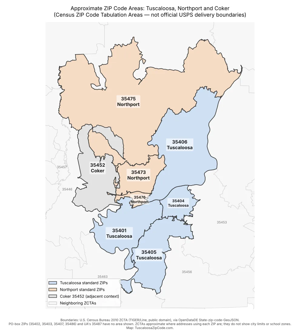
A Tuscaloosa ZIP code map is useful for getting a rough sense of where each postal code sits, but it is not a legal boundary map. The map below shows the approximate areas for Tuscaloosa’s four standard ZIP codes (35401, 35404, 35405 and 35406), Northport’s three (35473, 35475 and 35476), and the neighboring Coker code, 35452. The shapes come from U.S. Census Bureau ZIP Code Tabulation Areas. Those are statistical approximations, not the delivery boundaries the U.S. Postal Service uses.
This guide explains what the map shows and what it leaves out. It also covers how to read it without drawing the wrong conclusions, and which official tools to use when you need a definitive answer for a specific address.
What the Tuscaloosa ZIP code map shows
The map uses three colors. Blue areas are Tuscaloosa standard ZIP codes, tan areas are Northport standard ZIP codes, and gray marks Coker’s 35452, included as adjacent context. Neighboring ZIP areas outside the core set are drawn in light gray with small labels, including 35453, 35446, 35456, 35457 and 35463.
Here is a text description of the layout for readers who cannot see the image:
- 35475 (Northport) is by far the largest area. It covers the whole northern part of the map, reaching from the western edge to the northeast corner.
- 35406 (Tuscaloosa) is a large area that runs from the center of the map up toward the northeast. It sits east of 35473 and southeast of 35475.
- 35473 (Northport) is in the center-west. Coker’s 35452 lies to its west, 35406 to its east, and 35475 to its north.
- 35452 (Coker) is on the west side of the map, west of 35473 and south and southwest of part of 35475.
- 35476 (Northport) is a small area in the middle of the map, just north of where 35401 and 35404 meet.
- 35401 (Tuscaloosa) lies west and southwest of the center.
- 35404 (Tuscaloosa) is a smaller area on the east side, next to 35401 and north of 35405.
- 35405 (Tuscaloosa) stretches south from 35401 and 35404 down to the bottom of the map.
As a general rule, Northport’s ZIP codes are on the north side of the map and Tuscaloosa’s 35401, 35404 and 35405 are on the south side. That fits local geography. The Encyclopedia of Alabama describes Northport as sitting on the Black Warrior River across from Tuscaloosa, and notes that the name came from its spot on the north side of the river. The river itself is not drawn on this map, so do not use the map to judge which bank a particular address is on. The guide to Black Warrior River landmarks by ZIP code covers the river corridor in more detail.
ZCTAs vs. USPS ZIP codes: why the map is approximate
A ZIP code is not really an area. The Postal Service assigns ZIP codes to delivery routes and delivery points, meaning addresses, PO boxes and organizations, so it can sort and deliver mail. USPS does not publish polygon boundaries for ZIP codes.
To report statistics by ZIP code, the Census Bureau builds ZIP Code Tabulation Areas (ZCTAs). The method takes each census block, looks at the ZIP code used most often by addresses in that block, and assigns the whole block to that ZCTA. As a result, ZCTA lines follow census block edges, not postal routes. A few addresses near an edge can carry a ZIP code different from the shaded area they fall in.
The Census Bureau notes several more points that matter when you read any ZIP code map, including this one:
- ZCTAs can be noncontiguous, so one ZIP’s area can be split into separate pieces.
- Uninhabited areas larger than two square miles may be left out of any ZCTA.
- Not every valid ZIP code has a ZCTA.
- ZCTAs are revised with each decennial census. The map above uses the 2010 boundaries. The 2020 ZCTAs, built with the same method, may differ slightly near the edges.
Codes you will not see on the map
Tuscaloosa has five more ZIP codes that have no shaded area on the map. Four of them are PO-box ZIP codes: 35402, 35403, 35407 and 35486. They are used for post office boxes, not for neighborhoods or street delivery, so drawing them as areas would be misleading. The Tuscaloosa PO box ZIP codes explainer covers how they work.
The fifth is 35487, the University of Alabama’s unique ZIP code, which UA uses for institutional mail. The 2010 ZCTA set used for this map has no 35487 area. Many UA buildings publish physical addresses in 35401 instead, so do not read the blank spot as meaning campus has no ZIP code. The University of Alabama 35487 guide explains campus mail and street addresses.
Northport AL ZIP code map: reading the north side
On the Northport side, the map can give a misleading picture of size. Most of the northern half of the map is 35475, which covers a lot of rural and lake country in addition to developed neighborhoods. 35476 is small by comparison, but it holds addresses in historic downtown Northport, including the Kentuck Art Center at 503 Main Avenue. Large features can cross ZIP lines: Lake Tuscaloosa, for example, spans parts of 35406, 35473 and 35475. 35473 sits between Coker and the Tuscaloosa ZIP 35406.
The labels say “Northport” because Northport is the USPS primary city name for these codes. That does not mean every shaded acre is inside Northport city limits. A Northport mailing address only tells you how mail is routed. The complete guide to Northport ZIP codes walks through each code, and the Coker 35452 guide explains why the Northport Post Office also serves that code.
Land area and population by ZIP code area
The table below gives each area’s land size, calculated from the 2010 ZCTA file used to draw the map (land area only, water excluded). Population comes from American Community Survey (ACS) 2024 five-year estimates for each ZCTA, as reported by Census Reporter. Both columns describe the statistical ZCTA, not an official ZIP code or city population.
| ZCTA | USPS primary city | Land area, 2010 ZCTA (sq mi) | Population estimate (ACS 2024 5-yr) |
|---|---|---|---|
| 35401 | Tuscaloosa | 47.6 | 43,459 |
| 35404 | Tuscaloosa | 16.8 | 22,445 |
| 35405 | Tuscaloosa | 47.6 | 49,420 |
| 35406 | Tuscaloosa | 84.8 | 18,904 |
| 35473 | Northport | 25.2 | 18,198 |
| 35475 | Northport | 215.0 | 20,745 |
| 35476 | Northport | 5.5 | 8,521 |
| 35452 | Coker (adjacent) | 52.0 | 4,195 |
| 35487 | Tuscaloosa (UA unique ZIP) | No 2010 ZCTA | 1,950 (2020-based ZCTA) |
The figures show why area and population can point in different directions. 35475 has the most land by a wide margin but a population similar to 35404, which has less than a tenth of its land area. Census Reporter’s estimates come with margins of error that are not shown here. For the full figures, see the data.census.gov tables for each ZCTA.
What the map does not show: city limits and school zones
The most common mistake is to treat ZIP code shading as a map of something else. This map does not show:
- City limits. Parts of the “Tuscaloosa” and “Northport” ZIP areas are in unincorporated Tuscaloosa County. The City of Tuscaloosa offers a Zone Lookup app, linked from its FAQ page, for checking whether an address is inside city limits. The mailing address vs. city limits explainer covers why the two differ.
- School districts or attendance zones. Tuscaloosa City Schools and the Tuscaloosa County School System each run their own address-based zoning tools, and their lines do not follow ZIP codes. See the guide to Tuscaloosa and Northport school zones before assuming anything about enrollment.
- Property lines, streets or the river. For parcel-level detail, the Tuscaloosa County Tax Assessor hosts a public county GIS parcel map.
Official tools for checking an exact address
No Tuscaloosa ZIP code map, including this one, replaces an address check. When the exact code matters, for shipping, forms, deliveries or a lease, check the address itself:
- USPS ZIP Code Lookup. The USPS lookup tool returns the ZIP+4 code and standardized city name the Postal Service recognizes for a street address.
- Census Bureau maps. The Census Bureau’s TIGERweb viewer and data.census.gov let you view census geography and look up statistics by ZCTA. Remember that these show the same statistical approximations, not USPS routes.
- City and county GIS. Use the City of Tuscaloosa Zone Lookup for city limits and the county parcel GIS for property records. For Northport and other towns, Tuscaloosa County Public Works publishes a Planning and City Limits map; the county describes it as general reference, not survey grade, so confirm a result with the City of Northport or City Hall at 205-339-7000.
The step-by-step guide on how to find the correct ZIP code for a Tuscaloosa or Northport address goes through this process in more detail.
Frequently asked questions
Is there an official USPS zip code map for Tuscaloosa?
No. USPS does not publish ZIP code boundary polygons. Maps that show ZIP code areas, including this one, generally use Census ZCTAs or a commercial approximation. Use the USPS lookup for a definitive answer on a single address.
Why does my address appear in a different shaded area than its ZIP code?
ZCTAs assign whole census blocks to the ZIP code most common among their addresses, so addresses near a boundary can end up in a neighboring shaded area. The ZIP code USPS assigns to the address is what counts for mail.
Map credit and license
The boundaries come from the U.S. Census Bureau’s 2010 ZCTA5 file in its TIGER/Line series. As a federal government work, it is in the public domain, and the federal data catalog lists TIGER/Line datasets under a CC0 public-domain dedication. TuscaloosaZipCode.com used the GeoJSON copy published in the OpenDataDE State-zip-code-GeoJSON repository and drew the map from it. The Census Bureau has since released newer files, listed on its TIGER/Line page. The colors, labels and layout are this site’s own and do not represent any official boundary.
Facts in this guide were checked against the sources below on October 10, 2026. Addresses, programs and boundaries can change; confirm with the official source before relying on them.
Sources
- U.S. Census Bureau — ZIP Code Tabulation Areas (ZCTAs) (accessed October 10, 2026)
- U.S. Census Bureau — TIGER/Line Shapefiles (accessed October 10, 2026)
- U.S. Census Bureau — TIGERweb (accessed October 10, 2026)
- Data.gov — TIGER/Line Shapefile catalog entry (license information) (accessed October 10, 2026)
- USPS — ZIP Code Lookup (accessed October 10, 2026)
- City of Tuscaloosa — FAQs (“Am I in the city limits?”) (accessed October 10, 2026)
- City of Tuscaloosa — Zone Lookup app (accessed October 10, 2026)
- Tuscaloosa County Tax Assessor — Mapping Department (accessed October 10, 2026)
- Tuscaloosa County Public Works — Planning and City Limits map (accessed October 10, 2026)
- City of Northport — official website (accessed October 10, 2026)
- Kentuck Art Center — Visit (accessed October 10, 2026)
- Encyclopedia of Alabama — Northport (accessed October 10, 2026)
- Census Reporter — ZCTA profiles (35401 shown; same series for 35404, 35405, 35406, 35473, 35475, 35476, 35452, 35487), ACS 2024 5-year (accessed October 10, 2026)
- OpenDataDE — State-zip-code-GeoJSON (2010 ZCTA boundaries) (accessed October 10, 2026)
Leave a Reply